Bangladesh
Background Information
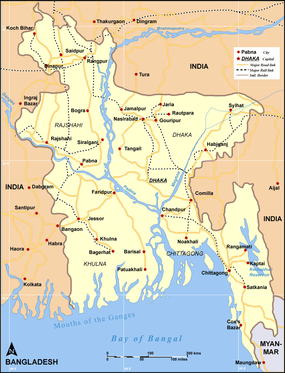
Bangladesh is located in Southern Asia in between Burma and India, bordering the Bay of Bengal. With a population of over 41.7 million people, Bangladesh is a populous country, well known for experiencing annual floods that have impacted on the country in various ways. Home to the world's 3 most powerful rivers, Bangladesh has an increased flooding propensity since the late 1990s. As a result, the country has been coping with various flood hazards, resulting in an economical crisis.
Economy
Despite having an annual economic growth of 5.8%, Bangladesh is still a Less Economically Developed Country (LEDC). The country is poor, overpopulated and inefficiently governed. The population below the poverty line in 2010 is about 31.5% of the whole population. The primary, secondary and tertiary industries division in 2008 are 45%, 30% and 25% respectively.
Geography
Bangladesh features a flat, low-lying terrain, subject to annual flooding. Its hilly terrain constitutes one tenth of the nation's land area. Much of the fertile soil is deposited by floodwater.
The total area of Bangladesh is 144,000 sq km, with much of it arable and forest or woodland (67-83%) . Permanent crops take up 2% of the total area and meadows and pastures 4%. Bangladesh is a land of rivers the criss crosses throughout the mostly flat territories of the country. Most homes built in the delta must be constructed on earthened platforms or embankments high enough to remain above the level of the highest floods. There are six seasons in Bangladesh, all of which have their own names in Bangladesh culture, they are: Grismo (summer), Barsha (rainy), Sharat (autumn), Hemanto (cool), Sheet (winter), Bashonto (spring). Bangladesh has a tropical monsoon type climate, hot rainy summers and dry winters. It has one of the wettest climates in the world with most places receiving 1525 mm of rain a year.
Bangladesh has a generally tropical monsoon climate. It has a mild winter from October to March, humid summer from March to June and humid, warm and rainy monsoon from June to October. Being located in South East Asia, 80% of Bangladesh is a flood plain, with 70% of the country being at least 1 m below sea level. Home to the world's 2 largest rivers, a vivid range of minerals flow down to the country from the Himalayas, depositing silt and sediment in the bank.
Overview of Bangladesh' Drainage Basin
The rivers of Bangladesh are very extensive and affect both the physiography of the country and the life of the people. Bangladesh is called a land of rivers as it has about 700 rivers including tributaries. Most of the river drainage basin is located in the neighboring countries and forms the Bengal Basin.
The figure below shows the Bengal Basin:
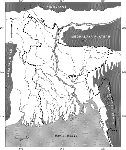
The rivers are not evenly distributed in the Bengal Basin. For instance, they increase in number and size from the northwest of the northern region to the southeast of the southern region.
Some of these rivers have the largest river length and volume of discharge on Earth. The rate of water flow through Bangladesh is tremendous. Moreover, the enormous volume of sediments that the rivers carry to the Bay of Bengal each year builds new land along the sea front, keeping hope alive for future extension of settlement. Hence, this great river system is the country’s fundamental resource as well as its greatest hazard. Furthermore, the Bengal drainage basin can be divided into five major river systems: the Tista river system, Brahmaputra-Jamuna river system, Ganges-Padma river system, Surma-Meghna river system, and the Karnafuli river system. The Tista river system is primarily the result of floods in Bangladesh, but also of land movement, earthquakes, and geological structural changes. The Tista river system originates in Chitamu Lake in the Sikkim Himalayas and enter Bangladesh at the Kharibari border. In hot seasons, most of the melted ice enters the Tista and flows directly into the Ganges. For instance, the excessive rains of 1787 and additional discharge from the himalayas created a vast flood bursting into the Ghaghat.
Some of these rivers have the largest river length and volume of discharge on Earth. The rate of water flow through Bangladesh is tremendous. Moreover, the enormous volume of sediments that the rivers carry to the Bay of Bengal each year builds new land along the sea front, keeping hope alive for future extension of settlement. Hence, this great river system is the country’s fundamental resource as well as its greatest hazard. Furthermore, the Bengal drainage basin can be divided into five major river systems: the Tista river system, Brahmaputra-Jamuna river system, Ganges-Padma river system, Surma-Meghna river system, and the Karnafuli river system. The Tista river system is primarily the result of floods in Bangladesh, but also of land movement, earthquakes, and geological structural changes. The Tista river system originates in Chitamu Lake in the Sikkim Himalayas and enter Bangladesh at the Kharibari border. In hot seasons, most of the melted ice enters the Tista and flows directly into the Ganges. For instance, the excessive rains of 1787 and additional discharge from the himalayas created a vast flood bursting into the Ghaghat.
Flood Control Technology
Flood Action Plan (FAP)
Following the consecutive floods during the 1990s, Bangladesh began to take part in what is known as a Flood Action Plan (FAP). This plan consists of 26 steps, and aims to minimize the extent of hazards and damage floods will cause to the country, with regards to the resources and funding the country has to deal with such natural disasters. Some main flood control plans Bangladesh has includes boats to rescue people, food storage systems for both the livestock and the people, as well as requesting aids from other countries when a flood arrives.
Embankments
One of the main infrastructures Bangladesh has made to reduce the damage flooding may cause, is the $6 billion dollar embankments they have made around their two largest rivers. The embankment, which is 7,555km long, 7m high, is a wall built from cobble, stone and earth, aimed at increasing the discharge of water the river channel can hold, reducing the risks of flooding in the process. The embankments were built since the 1960, and are considered the only long term plan Bangladesh has to reduce the chances of flooding. This allows more homes and cities to be built in the flood plains of Bangladesh, reducing the chances of flooding in the area. However, due to lack of workers and economic funding of resources, the embankments are not quite strong, and along with the great discharge and yearly floods Bangladesh is experiencing, there is a great chance that the embankments will erode and eventually collapse. However, as Bangladesh lacks funding and resources, they are unable to build any more flood control infrastructures to further protect the country from flooding hazards.
Flood Shelters
Aside from embankments, Bangladesh also has built 5000 flood shelters around the country to provide citizens with shelter, helping them survive from a flood. Additionally, a Flood Warning Scheme has been generated, involving signals and symbols around the country, to warn people about floods in time for people to make preparations and flee for safety. These schemes also provides farmers with time to protect their crops, get cattle and poultry out of harms way, reducing the harm it has on their agriculture and businesses.
Causes of Flooding in Bangladesh
Like many other countries in the world, floods in Bangladesh are caused by a great number of factors. These causes can be categorized into 2 main groups: Human Causes and Natural Causes. Below is a list of causes that led to flooding in Bangladesh, with a short explanation underneath for additional depth and detail.
Human Causes
Other than the natural causes, human activities can as well cause an area to be prone to flooding. They can affect the environmental factors such as land levels, soil conditions and forest density by altering its features into a state in which the flood can occur rapidly and rigorously. The main human causes for the river floods are urbanization, riverbed aggradation, ploughing and deforestation as explained below.
Rapid Urbanization
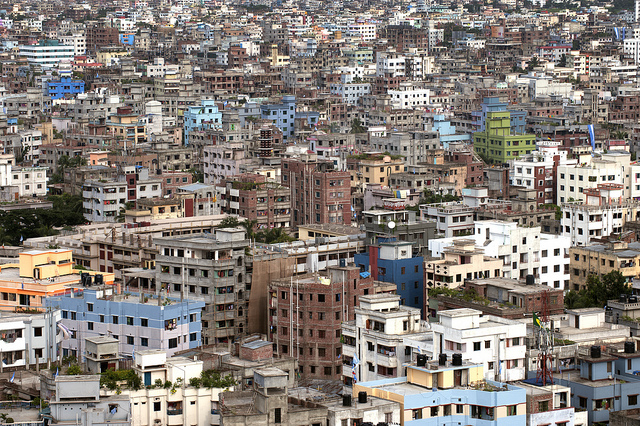
Rapid urbanization occurs when there is a sudden population growth. The population density in Bangladesh is increasing every year due to the drastic growth in population. According to the statistics, Bangladesh's population has increased from 1.81 million to 30 million within forty years since 1951. In 2013, the country population has exceeded the estimation: 50 million and have reached 163 million people. This unexpected rapid growth in population can impact the drainage basin and the flooding in the watershed through urbanization. Due to the constructions of buildings, flat lands as well as bare roads, it allows more water to enter the area and increase the drainage basin capacity. This can be viewed from the data where stated 60% of the lands are covered with high ways and buildings. As more and more people are moving in to the cities, agricultural lands that were initially providing a better condition for floods prevention are dominated by cements and other constructions. Consequentially, the lag time has been shortened and the peak flow has been increased making the urbanized city to be six times more susceptible to intense flooding.
Deforestation in the Upstream Region
Along with the rapid population growth, the rate of deforestation has been increased due to the increases in food and fuel wood demands. Especially the regions with steep slope that have deforested, landslides and soil erosion occur during the monsoon season. Specifically, deforestation on the uphill regions affected on the size and the scale of the floods. Such events will support the intensity of the flooding during heavy precipitation by accelerating the speed of water. Most of the time, the flooding in Bangladesh is blamed on the deforestation of Himalayan foothills. Deforestation of Himalayan foot hills allowed more rainwaters entrance to the Ganges and Brahmaputra, the two rivers in the vicinity of Bangladesh, with increased magnitude of the water flow that increased the intensity of the floods. In addition, absence of trees due to deforestation minimized the interceptions of the rainwater allowing it to travel along with the eroded soil, which increases the speed of the rainwater that allowed it to reach the ground level in a short amount of time.
Fresh Water Demand
The fresh water demands have been escalated with increased number of population in Bangladesh. One of the closest rivers to Bangladesh, the Ganges, has been widely used by the people living in the country. For instance, irrigation, industrial water supply and agriculture. These human activities done by using the water in the Ganges removed the silt from its river load, which ceased the natural construction of the floodplain that is made from the compiling of silt. The government in the country has also built for about 100,000 wells to satisfy the fresh water demands. The construction of the wells declined the water table and the land level by 2.5cm annually. As the land level has been subsided, the country has become more susceptible to the flooding increasing the flooding inundation.
Stability Of Flood Defenses
One minor human impact on flooding is the quality of the current flood defenses. Bangladesh is known to be in debt, which the country has insufficient expenses to construct flood protection measures. On top of that, the present flood defenses are ineffective and reconstruction are highly recommended. For instance, the level of the dyke as well as the depth of it are minimal resulting it to have insufficient storage capacity for rainwater. Furthermore, some areas of the floodplains are deforested that increased the speed of the waterflow. These vulnerable flood protection schemes are then corrupted during the flooding resulting in increase in debt and economic corruption. As a result of the poor condition of the flood defenses, levees are collapsed during the period of high discharge.
Economic Debts
As a result of Bangladesh's annual monsoon season, flooding incidents is inevitable in the country. As a result, Bangladesh is in an economic crisis, due to the great amounts of money it needs to repair the country before another flood occurs. Due to the damage floods have caused to the country, Bangladesh has no time to prepare or fully recover from the floods. As a result, its economy is constantly deteriorating and thus unable to repair or improve flood defenses and embankments they have set up in the country. This further increases the chances of a flood, and also makes the country less able to cope with flood disasters.
Rapid Urbanization
Rapid urbanization occurs when there is a sudden population growth. The population density in Bangladesh is increasing every year due to the drastic growth in population. According to the statistics, Bangladesh's population has increased from 1.81 million to 30 million within forty years since 1951. In 2013, the country population has exceeded the estimation: 50 million and have reached 163 million people. This unexpected rapid growth in population can impact the drainage basin and the flooding in the watershed through urbanization. Due to the constructions of buildings, flat lands as well as bare roads, it allows more water to enter the area and increase the drainage basin capacity. This can be viewed from the data where stated 60% of the lands are covered with high ways and buildings. As more and more people are moving in to the cities, agricultural lands that were initially providing a better condition for floods prevention are dominated by cements and other constructions. Consequentially, the lag time has been shortened and the peak flow has been increased making the urbanized city to be six times more susceptible to intense flooding.
Deforestation in the Upstream Region
Along with the rapid population growth, the rate of deforestation has been increased due to the increases in food and fuel wood demands. Especially the regions with steep slope that have deforested, landslides and soil erosion occur during the monsoon season. Specifically, deforestation on the uphill regions affected on the size and the scale of the floods. Such events will support the intensity of the flooding during heavy precipitation by accelerating the speed of water. Most of the time, the flooding in Bangladesh is blamed on the deforestation of Himalayan foothills. Deforestation of Himalayan foot hills allowed more rainwaters entrance to the Ganges and Brahmaputra, the two rivers in the vicinity of Bangladesh, with increased magnitude of the water flow that increased the intensity of the floods. In addition, absence of trees due to deforestation minimized the interceptions of the rainwater allowing it to travel along with the eroded soil, which increases the speed of the rainwater that allowed it to reach the ground level in a short amount of time.
Fresh Water Demand
The fresh water demands have been escalated with increased number of population in Bangladesh. One of the closest rivers to Bangladesh, the Ganges, has been widely used by the people living in the country. For instance, irrigation, industrial water supply and agriculture. These human activities done by using the water in the Ganges removed the silt from its river load, which ceased the natural construction of the floodplain that is made from the compiling of silt. The government in the country has also built for about 100,000 wells to satisfy the fresh water demands. The construction of the wells declined the water table and the land level by 2.5cm annually. As the land level has been subsided, the country has become more susceptible to the flooding increasing the flooding inundation.
Stability Of Flood Defenses
One minor human impact on flooding is the quality of the current flood defenses. Bangladesh is known to be in debt, which the country has insufficient expenses to construct flood protection measures. On top of that, the present flood defenses are ineffective and reconstruction are highly recommended. For instance, the level of the dyke as well as the depth of it are minimal resulting it to have insufficient storage capacity for rainwater. Furthermore, some areas of the floodplains are deforested that increased the speed of the waterflow. These vulnerable flood protection schemes are then corrupted during the flooding resulting in increase in debt and economic corruption. As a result of the poor condition of the flood defenses, levees are collapsed during the period of high discharge.
Economic Debts
As a result of Bangladesh's annual monsoon season, flooding incidents is inevitable in the country. As a result, Bangladesh is in an economic crisis, due to the great amounts of money it needs to repair the country before another flood occurs. Due to the damage floods have caused to the country, Bangladesh has no time to prepare or fully recover from the floods. As a result, its economy is constantly deteriorating and thus unable to repair or improve flood defenses and embankments they have set up in the country. This further increases the chances of a flood, and also makes the country less able to cope with flood disasters.
Natural Causes

Flooding is a natural phenomenon in Bangladesh and occurs on an annual basis. Some physical features of Bangladesh, as well as human causes also allow the country to be subject to these large floods which bring about severe damages to the country costing millions of dollars. Below is a list of the significant causes of flooding, including it's climate
Monsoon Climate
Bangladesh has a monsoon climate, bringing heavy rain and snow and thus causes main rivers to overflow between monsoon seasons during July and mid-August. Soils are leached and heavy runoff results in soil erosion. The convectional rainfall of the monsoon is added by the relief rainfall caused by the Himilayas, as melting water is also a significant input to the flood every year. As an example, a normal monsoon downpour in the Ganges, Brahmaputra-Meghna drainage system was thought to be the primary cause of the 1988 flood in Bangladesh, inundating 82,000 sq. km of land, or approximately two thirds of the nation. Although it is not known whether the heavy downpour was an effect of other processes such as the greenhouse gases or destruction of forests in the upstream region.
Tectonic Uplift
The tectonic uplift of the himalayas means that erosion rates of sediment increases as the rivers have more potential for erosion. This mass of residue is dumped in Banglaesh choking the river channels and thus making them more inefficient in reducing hydraulic radius.
Relief Runoff
In Bashonto (spring) and hot seasons, snow in Himalayas melt and flow down the rivers into Bangladesh, increasing discharge via the Tista and Ganges river system. While the monsoon seasons always bring flooding in Bangladesh, major river systems are frequently filled up with melting snow in the Himalayas. Deforestation may be partly to blame, causing soil erosion which reduces the ability of the land to absorb water. According to climate experts, global warming is partly to blame, by increasing monsoon rainfall and speeding up the melting of Himalayan snows.
Sea Levels
The ultimate destination of all rivers is the ocean. The land elevation is measured with regards to the sea level in an area. Hence, any change in sea level also causes land elevation to change. At present, sea levels are rising globally. If the sea level rises in an area at a rate faster than the rate of land deposition due to sedimentation, then land elevation decreases. This also results in inundation by rivers when they overflow. The rate of local relative sea level rise is approximately 7mm/year around the coastal area of Bangladesh. Furthermore, an increase in sea level raises the base level of rivers, which in turn reduces the gradient of river flow.
River Processes
Some are some of the river processes occurring in the river systems that allow Bangladesh to be prone to flooding.
Erosion
River erosion and submerging of the coastal islands are the national phenomenon being one of the main natural disasters. Ploughing makes the land surface more susceptible to soil erosion. Surface run-off can easily wash away the topsoil from the surface of land. This surface erosion in turn reduces land elevation and thus increases flood intensity in an area. The Centre for Environment and Geographic Information Services (CEGIS) shows in a recent research that 0.1 million people become homeless every year in the country due to river erosion. In the last 34 years submerging of river side lands are 219,286 acres in river Jamuna, 69,135 acres in river Ganges and 93,119 acres in river Padma. As of 2001, it was predicted that if the rate of erosion in river Jamuna continued it would cause 3408 acrea of land, 543 localities, 3360 metres of embankment, 5160 metres of roads, 4 educational institutions and 2 market places to be submerged by 2007.
Causes of Erosion
- Immense pressure of downward tides and intensity of waves cause erosion to coastal islands every year. Coastal estuaries and channels are filled with approx 30868 cubic metres of tidal water.
- As the result of greenhouse gas emissions the atmosphere is getting warmer day by day resulting in glacier liquifying. The huge quantities of melted water from the Himalayas are speeding up through the Ganges and Brahmaputra and crashing to the coastal estuaries of Bangladesh. The intensity of tidal waves causes erosion in the south-western coast of Bangladesh.
- Lack of national forecasting system for the erosion.
- Coastal areas of Bangladesh are submerged due to the global warming and sea level rise. The collision between downwards current of fresh water and uprising sea level creates strong twirling that causes erosion to the coast.
- Due to combined sudden flood, heavy rain, and downwards freshwaters causes collision to the riverbank and cause erosion to the coastal areas.
- Deforestation and removal of mangrove protection. Mangroves are continually destroyed by the Shrimp culture and salt fields.
- Unseen change in the tidal surge due to the climate change.
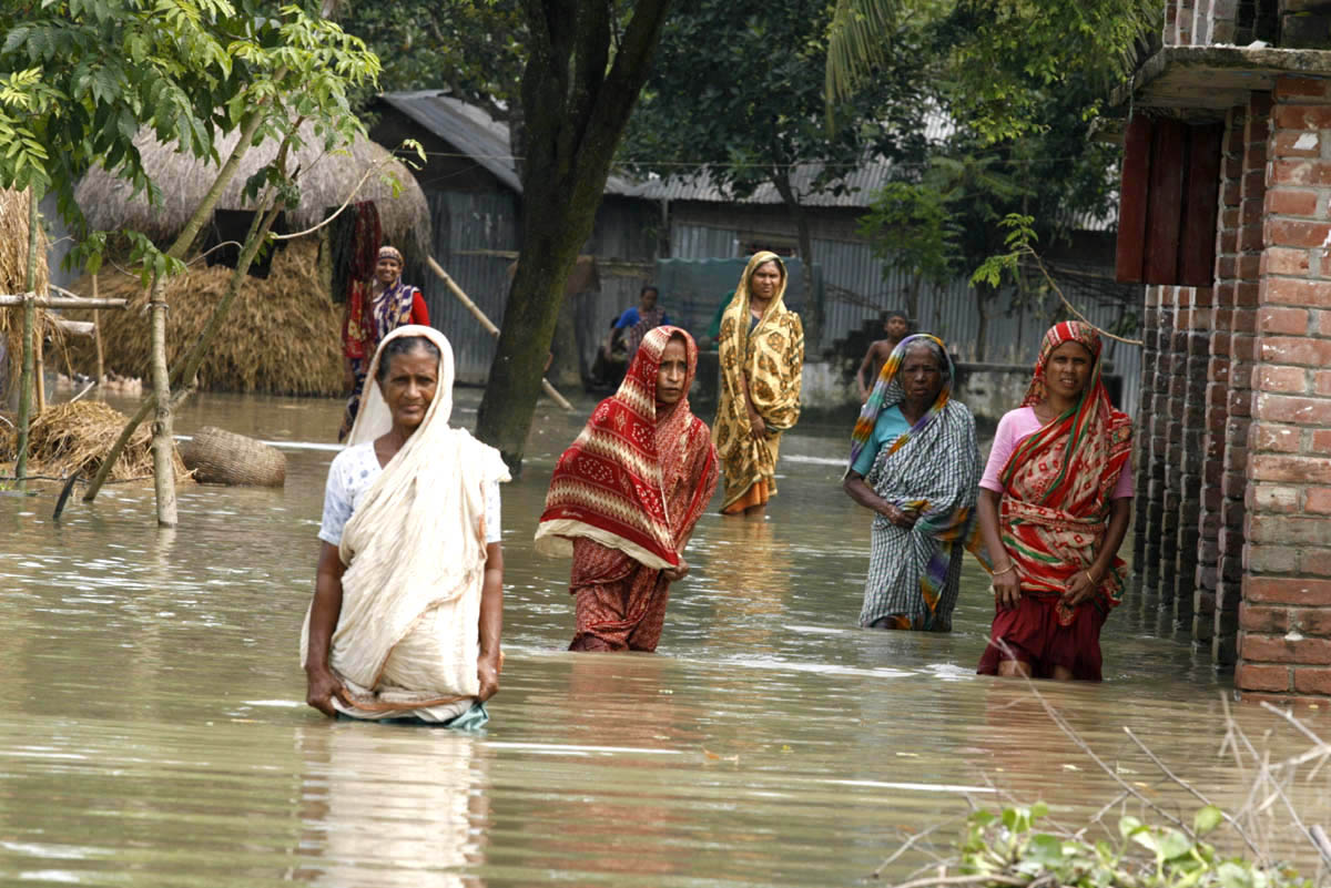
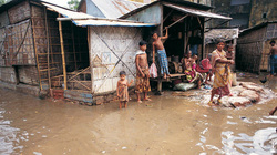
Impacts of Flooding on Bangladesh
Over the years, Bangladesh has been affected by floods in various ways. Having experienced annual floods during the rainy season, Bangladesh is said to have "experienced some of the worst floods in history." Below are examples of major flooding incidents that have occurred in Bangladesh, with full coverage of the causes and effects of these floods on the country.
1998 Flooding Incident (July - September)
The flooding incident during 1998 was mainly caused by the ice caps melting in the Himalayan Mountains. The melting snow flowed down the Ganges and Brahmaputra mountains connected to Bangladesh. At the same time, a heavy monsoon occurred in the north eastern part of the country, causing large amounts of precipitation and water discharge in these areas. Being a less economically developed country (LEDC), Bangladesh was in debt, resulting in minimal, ineffective flood defenses and flood protection measures. Many regions surrounding the Himalayan foothills were deforested and urbanized to keep up with the population increase in the country, resulting in greater surface runoffs and a great decline in interception. With 80% of the country being a flood plain, and over 50% located below sea level, Bangladesh was unprepared for this natural disaster, hence causing major damages to the country.
Size and Scale of Flood
The flood was said to have covered over 57% of the country, destroying 7 million houses and contaminating at least 2 million tonnes of rice. Nearly half a million cattle and poultry was lost or killed from the flood, with some people claiming this incident as “1 of the most destructive flood incidents” to have ever occurred in the country.
Effect on the People
News reports from BBC stated that at least 1,300 citizens were killed during the incident, with an additional 25 million others displaced and left homeless. The flood deposited mud and soil into the country's sewage system, causing a huge shortage in drinking water and dry food. As people were forced to drink contaminated water, many suffered from diseases such as Diarrhea, Bronchitis, and Cholera. Electricity supplies were closed, and a number of roads and bridges were damaged and unusable. Rural villages were isolated from major cities, causing exports and resource production to decline. Statistics showed that exports and production in the country dropped by nearly 80%, with many farmers being jobless and impoverished as a result of the flood. It was said that repairs costed the country almost $1 Billion dollars, leading the country in debt.
Positive Impacts
Like many of Bangladesh's flooding incidents, the discharge and velocity of water flowing down the three largest river systems in the country deposited fresh nutrients, silt, and other minerals, providing the country with a vast range of natural resources. This was beneficial to Bangladesh's economy, as it slightly boosted its economy and pay for the repairs it needed.
Implementing Flood Control Systems
Following this incident, the Bangladesh government has announced that it will begin to take measures to reduce flood risks and minimize the damage it will cause to the country. The Flood Action Plan (FAP) was made, which consisted of 26 steps which outlined what people should do in case of a flood incident (refer to Flood Control Technology). The country also invested into flood infrastructures, such as embanments and dykes, as well as flood warning systems to keep the community informed about floods and heavy monsoons. However, due to the country's failing economy, these infrastructures and plans were not maintained or regulated. As a result, it has became one of the human causes of flooding in the country (refer to Human Causes).
2004 Flooding Incident (July - August)

The 2004 flooding incident was quoted as the "worst flood in 6 years." Aside from the heavy monsoons that the country experiences, this flood was said to have also been caused by melting snow in the Himalayan Mountains, which caused a sudden rise in river discharge. Additionally, the country's excessive urbanization has also led to rapid deforestation, which is quoted to have "[caused] soil erosion......which reduces the ability of the land to absorb water." (BBC. 2004). Being an LEDC, many people were impoverished and were unable to develop better infrastructures and technology to protect the country from flooding, following the 1998 incident. As a result, many civilians suffered from the natural disaster.
Size and Scale of Flood
The flooding incident was said to have covered at least 60% of the country, affecting an estimated 140 million people. The flood caused mud to mix into the country's sewage water, meaning there is no clean water for people to drink. 2.6 million homes, 11,000 schools, 3,000 bridges, and 30,000 km of roads were destroyed. Many people are forced to stay in flood shelters, as the flooding has blocked off roads and pathways, making it hard for people to travel about. Many electrical wires and cables sunk into the water, making it dangerous for civilians to move about. The flood lasted for nearly a month, as rain continued to precipitate following the first flood. This incident, has prompted the United Nations to take action, as they have provided resources in hopes it can help those in need. This shows how great of an issue the flooding incident was, as numerous countries have been donating supplies to help Bangladesh cope with this natural disaster.
Effect on the People
Many people have been affected by the flood in numerous ways. At least 30 million people are homeless and stranded, with another 600 people found dead from the flood. Many people have been forced to drink the muddy flood water for survival, of which has caused massive outbreaks of diarrhoea. News reports from BBC, for instance, have stated that 100,000 people showed symptoms of diarrhoea 1 day after the flood, and numbers were expected "to rise sharply in the coming weeks." (BBC. 2004). In total, the costs required to repair all the country's facilities went up to 4 billion euros, further leaving the country in debt.
2012 Flooding Incident (June - August)
Being one of the most recent floods that has occurred in Bangladesh, the main cause for this flood was mainly due to the heavy monsoon season the country was experiencing. Along with the ongoing flood that has taken place since 2004, it has been shown that the constant cycle of flooding has made it nearly impossible for people to recover. The poor flood warning systems and inefficient flood defense systems provides people with inadequate time to prepare for the flood. Another cause for this incident, is the fact that the countries donating resources and supplies for Bangladesh decreased. This is mainly because they believe that Bangladesh "flood-affected people have learnt to cope" and don't think it is necessary to help them. (Al-Mahmood. 2012). However, with the weakened economy, it is becoming increasingly hard to overcome such incidents. As a result, this flooding incident has also cause an immense impact in the country.
Size and Scale of Flooding
Reports have shown that the flood lasted for over six weeks, arriving just after the harvest and dry season rice crops. The flood mainly occurred in the North-Eastern part of the country, with reports from researchers in Chittagong (Bangladesh's second largest city) stating that they received "40cm (15.75in) of rain in a single 12-hour period on Tuesday, one of heaviest days of rainfall over the last five years." (BBC. 2012).
In addition to the rainfall, tinned-roof houses and mud banks were said to have been destroyed. Numerous landslides have occurred as a result of soil erosion caused by flooding and precipitation. Communication have been disrupted as a result of the damage caused by the flood, with reports showing that lightning storms is causing severe damage to the area, and possibly electrifying the flood water, making it even more dangerous.
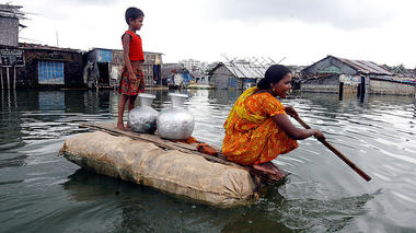
Effect on the People
Approximately 110 people were killed from the flood, with another 53 being killed by landslides during the same time period. An estimated 600,000 people were displaced and stranded between June and July, with a number being forced to stay in high rise buildings to avoid the flood. The long monsoon season has inhibited farmers from planting next season's crops, blocking off roads and preventing them from selling their crops to the market. As a result, many farmers are growing impoverished, with a large percentage of them falling below the poverty line. Firewood, the main source of fuel in these flood-affected communities, are wet and damp as a result of flooding and high levels of precipitation. Civilians are unable to light them up and are forced to live without heat or light, meaning that they have to eat raw food and drink unclean water. Families lost valuable income, and homes are receiving poor sanitation as a result of the long monsoon floods. Civilians have no source of food or water, struggling to survive until the flooding stops.
Approximately 110 people were killed from the flood, with another 53 being killed by landslides during the same time period. An estimated 600,000 people were displaced and stranded between June and July, with a number being forced to stay in high rise buildings to avoid the flood. The long monsoon season has inhibited farmers from planting next season's crops, blocking off roads and preventing them from selling their crops to the market. As a result, many farmers are growing impoverished, with a large percentage of them falling below the poverty line. Firewood, the main source of fuel in these flood-affected communities, are wet and damp as a result of flooding and high levels of precipitation. Civilians are unable to light them up and are forced to live without heat or light, meaning that they have to eat raw food and drink unclean water. Families lost valuable income, and homes are receiving poor sanitation as a result of the long monsoon floods. Civilians have no source of food or water, struggling to survive until the flooding stops.
Other Effects of Flooding
Poverty
As a result of flooding, many people are forced below the poverty line. In an article from The Guardian, it was mentioned that "studies carried out after a major flood in 2004 showed that flooded households often fall into a vicious cycle of debt and roughly a fifth of flood-hit families are pushed below the poverty line." (Al-Mahmood. 2012). With 80% of Bangladesh living in rural areas, and 54% of the population relying on agriculture as their main source of income, the harvest and growing of crops is crucial for many families to survive. However, due to the annual floods and monsoons, many families are struggling to harvest their crops or even sell it to the market, as flooding causes the soil to erode, contaminates the crops, and also blocks off roads leading into the city. Many people living in rural areas are isolated, thus becoming increasingly poor and economically unstable after each flood.
Malnutrition
Being heavily reliant on agriculture, many people living in Bangladesh rely on vegetation as their main source of nutrition. However, as a result of flooding, many crops and plantations have been washed away or contaminated, forcing civilians to starve and possibly die from famine. Surveys conducted on the North-Eastern district of Bangladesh have shown that "more than 90% [of the flood-affected families in Bangladesh] sometimes reduce the size of their meals, and close to 60% sometimes skip a meal altogether." (Al-Mahmood. 2012). Presently, 55% of the children in Bangladesh aged 5 or below are underweight, mainly resulted from the hazards that floods have caused to the plantation of crops in the area. The lack of clean food and water reduces the nutrition that citizens need to survive, hence making them more prone to diseases, leading to various health issues.
Fishing
As a result of flooding, Bangladesh's economy is becoming economically unstable. Being unable to grow crops or vegetations, many farmers have resorted to fishing, as the overflow of water has provided them with adequate supplies of sea life that they believe will help sustain their income. However, due to the country's poor economic development, the government has began to lease their rivers and lakes to big contractors, whom sets these areas as their private property. As quoted by a flood-affected civilian following the 2012 flood, "the rivers and lakes are off limits to us because the government has leased them out to big contractors...We can't catch fish any more. So if the crops fail due to a flood, we have to starve." (Al-Mahmood. 2012). Although this may benefit Bangladesh's economy, it also poses various issues to many families, as they do not have any source of income after their crops are destroyed. The inability to fish further pushes them below the poverty line, and also forces them to starve and possibly die.
