Netherlands
Background Information
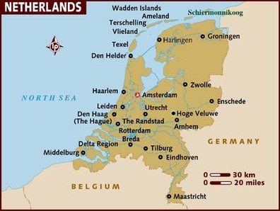
The Netherlands is located in Western Europe in between Germany and Belgium, bordering the North Sea. With a population of 16.7 million people, and a total land area of 41,526 sq km, the Netherlands is well known for its highly advanced flood control technology that aims to protect the country from "catastrophic storms that only occur once in 10,000 years."
Economy
The Netherlands economy is the sixth largest economy in the euro-zone. The country has a great industrial relationships with the foreign countries and have minor unemployment and inflation activities. The country has a fairly high GDP per capita of 42,300 US Dollar (2012). The primary, secondary and tertiary industries division are 2%, 18% and 80% respectively in 2005. The population below the poverty line are 10.5% of the whole nation.
Geography
The Netherlands occupies part of the Great European Plain and is predominantly flat. In most places, the surface consists of either glacier-deposited sand, gravel and clay. Roughly half the land lies below seal level, the rest rises only slightly above sea, rarely to more than 300 feat. Crisscrossing the land are many rivers, canals and drainage channels that interconnect. In some areas, waterways flow in embanked channels above the level of the adjacent land. The Rhine, Meuse and Schelde (Holland’s three chief rivers), flow to the North Sea through a delta area in the south. They reach the sea by numerous distributaries or branches. To protect against disastrous flooding, such as that of 1953, enormous concrete barrers with movable gates to control sea and river water levels were built in the delta channels as part of the “Delta” Project. After nearly 30 years of construction, the project was completed in 1986. The Netherlands has a maritime type of climate similar to that of the coastal areas of Washington and Oregon. Summer are cool, winters are normally mild.
Overview of Netherlands' Drainage Basin
The Holland river drainage basin is located in the southwestern corner of the Lake Simcoe watershed and occupies a land area of approximately 597 sq. km or 21% of the total area of the watershed. The river flows north from its origin in the Oak Ridges Moraine and outlets into the southern most tip of Cook Bay. The headwaters elevation is approximately 336 metres above sea level. Below is a figure showing its drainage basin:
Flood Control in Netherlands
Following a flood during the early 1500s, Dutch inventors in the Netherlands began to create various infrastructures to protect the country from similar floods. These infrastructures help prevent long term flooding and disasters within the country, aimed at protecting the country from floods for up to 10,000 years.
Artificial Dwelling Hills
Artificial Dwelling Hills, also known as terpins, were built in Netherlands for the purpose of increasing the elevation of land, such that houses and villages can be built in a safe environment, away from floods. Mainly built with stone and cobble, the terpins were later used to deposit waste and rubbish from these houses, acting as compost that helped improve the soil quality in these areas. It also helped solidify the land, making the hills more sturdy. As time passed, the hills were raised to increase the land elevation, further protecting from villages from floods. Although these dwelling hills are not commonly used anymore, some are still preserved and are still present to this day.
Dikes and Sluices
Since the 1730s, dikes, a long wall built to prevent flooding from the sea, were built in surrounding areas of Netherlands where homes are close to the ocean. These dikes are built with a slope, of which is said to give the wall extra durability, allowing it to withstand more discharge compared to many other dikes in the world.
Sluices, on the other hand, are dikes built between 2 bodies of water. In the Netherlands, these walls, which are semicircular in shape, are built to open and close at any time, equipped with sophisticated monitoring systems that help sense water movement in surrounding areas of the dykes. The sluices close when the water level rises by 3 meters, and following the 1935 flood, it has been considered the "safest levee system in the world." (eHow. n.d.).
Flood Evacuation Scheme
Similar to Bangladesh, the Netherlands have created a scheme that alerts citizens of possible floods 24 hours before it hits the country. With the given procedures, this provides enough time for citizens to prepare their belongings and evacuate safely. The 24 hour period has been made possible, due to the Netherlands' highly advanced flood control technology, as well as its developed communication systems.
Causes of Flooding in Netherlands
Similar to Bangladesh, flooding in Netherlands can be divided up into 2 categories: Human Causes and Natural Causes. Below is a list of causes that leads to flooding in the Netherlands.
Human Causes
Although floods are noted as a 'natural' hydrological disaster, we humans are also partially responsible for these hazards. Human actions can affect the environmental landscape and the rivers in a drainage basin system, increasing the risks of flood in a particular area.
Urbanization
Urbanization is one of the major causes of flooding in Netherlands. Being one of the world's most densely populated countries, the urban population in the Netherlands accounts for 82.9% of its total population. Being so populated, a great number of buildings, roads, and cities have been built to provide citizens with shelter and adequate resources. However, this has caused vegetation to be destroyed, decreasing the interception of rainfall when a storm is to occur. Additionally, the excessive use of tar and cement to pave roads and sidewalks inhibit water from infiltrating the soil. These artificial structures are impermeable, and water is forced to flow back into the ocean through surface runoff, increasing the peak discharge in the area. Due to this, the lag time for water to flow back into the ocean has decreased, increasing the chances of flooding.
Land Reclamation and Polders
Land Reclamation has played a huge role in urbanization and industrial development in the Netherlands. Statistics from 2007 showed that up until the 20th Century, 1650 km2 of land was reclaimed and drained for agricultural, industrial and recreational purposes. Polders in particular are types of reclaimed land with protected by dykes. Although this would allow the country to expand upon its economy and urban population, it also makes the country more prone to flood hazards. As the reclaimed land was original found underneath water, it is not exactly stable and is mainly composed of sand, saturated soil, and clay. As water has to be physically drained in order for the land to be used, the land elevation is quite low, making it prone to flooding. Additionally, the lack of soil and plants makes these ares less sturdy and strong. Since they are close to the shoreline, they are more prone to coastal waves, which erodes these areas and weakens it. Although land reclamation doesn't exactly cause a flood, the country's land is sinking below sea level, hence becoming more prone to floods.
Quarrying and Mining
In order to retrieve adequate natural resources, a large portion of polders and reclaimed land have been exploited for quarrying and mining. The purpose of this is to retrieve peat, salt and fuel from the ground. In many cases, these tasks remove all the vegetation and permeable soil in the area, decreasing the groundwater flow and throughflow of rainwater. Clay, an impermeable sediment, resurfaces in such areas, increasing the chances of surface runoff. This means the lag time for water to return to the ocean is shortened, increasing the risks of flood in the process.
In addition to the resurfacing of clay, quarrying has also physically changed the geographic contour of land in many parts of the Netherlands. Presently, 12.2% of the total land in the Netherlands have been invested into quarrying and mining industries, which is used to exatract limestone, salt and slit. However, by digging deeper into the ground, the land elevation in the country gradually decreases, causing more land to fall below sea level. Statistics conducted by the University of Amsterdam has shown that quarrying and mining is causing "ground levels [to fall] dangerously below the mean sea level." (Kraker. 2006). Research has shown that in 2007, 27% of the country was below sea level, but in 2012, this number increased to almost 50%. This change in land configuration makes it more difficult for water to travel back into the ocean, causing it to stay trapped in the drainage basin for a long period of time. As a result, the country is becoming increasingly prone to coastal flooding and excessive discharge from heavy precipitation, increasing the risks of flooding.
Deforestation
Deforestation is one of the main causes of flooding in the Netherlands. A large portion of vegetation and forested areas have been removed for the sake of urbanization and providing land for agriculture and ploughing. Statistics have shown that in 2008, 12% of the country was made up of woodland. However, this number dropped to 10.8% in 2010. This change in forestation has caused more permeable soil and rock to erode, causing clay and granite, impermeable sediments, to resurface. Deforestation also minimizes the interception of rainfall in the country, as there are less trees and vegetation to 'catch' precipitation before it infiltrates the soil. This further shortens the lag time, increasing the chances of flood in the country.
Agriculture and Ploughing
Being the world's second largest exporter of agricultural products, agriculture plays an immense role in the Netherlands' economy. Presently, 70% of the country's land is used for agricultural purposes, with statistics showing that an additional 7000 hectares of land have been invested for agricultural purposes between 2006 and 2008. Although agriculture has benefitted the country's economy, a great number of forests have been cleared to provide land for such causes. This has led to a decrease in interception of rainfall, shortening the lag time in the process. Additionally, the ploughing of land in such areas exposes soil to the various weather conditions in the country. This makes the soil more prone to saturation during a storm, increasing the chances of surface runoff. During the dry season, the soil solidifies and become almost impermeable. Precipitation is unable to percolate or infiltrate the soil, hence increasing the chances of surface runoff. As the soil is not held in place by vegetation, it is prone to erosion both by rainwater and strong winds. As a result, the layer of permeable soil becomes thinner, decreasing the percolation, infiltration, and groundwater flow in these areas.
Flood Control Infrastructure
Many infrastructures, including embarkments, dikes, and polders, have been eroded by tidal waves and high water velocity. Many pieces of clay, silt, cement, and rock used for constructing these structures are deposited in the riverbed, causing riverbed aggradation. This means that the discharge a river can hold has decreased, increasing the likelihood of floods in the process.
In addition to the deposition of clay and other forms of sediment, depending on the quality of artificial dykes and levees, these barriers are only able to prevent flooding to some extent. In time, these barriers will erode and become unable to block off water, causing water to breech through and resulting in increased damage to surrounding areas. This was particularly evident during the flood in January, 2012, when 100 people were forced to evacuate after being told that a nearby dyke was about to collapse. This however, is only a minor cause of flooding in the Netherlands, as people from the DeltaWorks are regulating these infrastructures on a yearly basis. Dykes and levees are constantly being replaced or refined, as of to provide better protection for the country.
Natural Causes
Flood control is an important issue for the Netherlands, as two-thirds of its area is vulnerable to flooding, while the country is among the most densely populated on Earth. Natural sand dunes and man made dikes, dams and floodgates provide defense against storm surges and flooding. With 41526 sq. km, the Netherlands support a population of just under 16.5 million people, making it one of the most densely populated countries in the world. If flooding occurs on a mass scale many people will be displaced from their homes and workplaces. Rising sea levels could wreak havoc on the Dutch way of life. The people, economy, and land itself, would be swept away, costing the Dutch their livelihood and possibly their lives. Below are the natural causes of flooding in the Netherlands.
Coastal Lowlands
Coastal lowlands are considered most vulnerable to sea level rise. In this respect, Netherlands, where more than 85% of the coastal zones is located below 5 metres elevation and is therefore highly vulnerable. Moreover, sea lever rise and the increased likelihood of severe storm surges are projected to be the highest in the North Sea region. Hence, the safety of the Netherlands is dependent on reliable flood protection structures. Failure of flood defences could have serious devastating human and economic consequences as was proven by the damages caused during the North Sea Flood of 1953. A combination of a high spring tide and a severe windsotrm resulted in local water levels of more than 5.6m above sea level. 1835 people died as a consequence of this flood, with almost 200,00 hectares of land inundated and 3000 homes and 300 farms destroyed.
Sea Levels
The threat of sea level rise due to climate change will test the country’s flood protection system. The IPCC predicts that there will likely be increased incidence of extreme high sea level events in the 21st century. Global warming has caused the Earth’s polar regions to be much warmer for longer periods of time. Melting glaciers and polar ice caps 125,000 years ago increased sea levels by 4 to 6 meters.
Climate Changes
Changes in climate and weather patterns will exacerbate the already rising sea levels. Storm events over the North Sea are often powerful and unpredictable. Althought the Netherlands does not experience hurricanes, similarly strong events could cause major damage and loss of life. New Orleans, like most of the Netherlands, lies below sea level and possess a series of flood control mechanisms. Unfortunately, New Orleans sustained a direct hit from one of the worst hurricanes in US history. Hurricane Katrina caused 1833 fatalities over five states resulting in a total economic loss of 81 million dollars. Evacuation efforts were slow and resulted in long back-ups on certain areas. Although New Orleans is heavily populated, the Netherlands population density is higher over a larger area. Most people rely on public transport to get around town and surrounding areas. Evacuation efforts in the Netherlands would have to be well planned and executed to avoid the difficulties that were seen during the Hurricane Katrina in the United States.
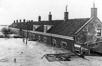
The River Rhine Floods (1994 November~ 1995 February)
The Rhine Floods was known to be one of the worst floods during the 20th century that has caused great loss in numerous regions in Europe. The scale of the floods was significant due to the size of the Rhine river. The Rhine river is the major channel of European continent. During the time of the flooding, the only protection the Dutch people had in case of floods was the dykes. While 15 million people in the Netherlands live below the sea level, the river Rhine and its tributaries, the Meuse and the Mosel, attacked the three countries including Holland- Belgium and Luxembourg. Such catastrophe was investigated that its causes are mainly due to the immediate heavy rainfall and a relatively mild temperatures during the periods, which has caused to melt the mountain snows massively.
Size and Scale of Flooding
Regarding the news report, the Rhine floods have lasted for about three months. When the water in the Rhine river entered the Netherlands from Germany, the level increased greatly to about 14 meters above the sea level. The discharge along the Rhine river has increased up to 11,500 meter cube per second from 2,200 meter cube per second within 18 days. The Rhine river attack has killed 4 people and 250,000 of the citizens had to be evacuated. The empty houses left as a result of these were guarded by the police during the period of recovery. Not only did the people had to evacuate the area, one million cattle were evacuated as well, reducing the yields of milk and some were found infected by foot rot. Furthermore, the majority of large cities and tracts were submerged and other flooded greenhouses lead to the substantial loss in the stock of florals, vegetables and fruits.
Effect on People, Environment and Living Conditions
Numerous people were affected from the incident. Not only did it affect the people in the Netherlands but it has also affected the other low land countries in the vicinity of the Rhine River such as Belgium and Luxembourg. Four people were found dead and millions of people as well as the animals were affected. Hundreds of homes were inundated resulting people from some regions to move out. Numerous farmers have experienced great loss in crops and their own lands as the floods have flooded approximately 1,500 kilometer square of the farmlands. In addition, the Rhine floods have disrupted the water condition that water supplies were insufficient for people's usages. Silt and polluted mud were deposited to the floodplain making it impossible to grow further yields of crops and other vegetables. As significant amount of loss were seen, the country have also encountered an economic issue. According to the research, it was found that the total cost of the damages made as a result of the River Rhine Floods is over billions of euro. This have resulted a huge strain on the country's economy. Many parts of the country, especially the cities, were left to be reconstructed. For instance, the underground park, schools, subways, roads, underpasses as well as some of the houses.
After the flooding, the government and the people have came up with better solutions and precaution for the possible unprecedented floods. The government has decided to manage the Rhine basin with its duty given to the international co-operation for flooding control. After the causes of the floods have been thoroughly studied, the country has put in action to afforestation as the trees can intercept the great amount of rain and decrease the lag time. In the urban area and mainly the ones that are susceptible to flooding were limited to the residential development. Previous dykes have been reinforced by changing it from earth material to steel piling. Moreover, the country allowed the river to flow back to marshland area, the former region of where the water flow through, to decrease the velocity of the water flow by supporting the silt and depositions within the river. A billion dollars in total were spent on the general flood protection plan after the River Rhine floods.
Reinforcing Flood Protection
After the damages made by the floods, the Netherlands have worked on fortifying the condition of the dykes. Not only did they have increased the height of the dyke but also on widening it. Considering the greenhouse effects increasing the overall precipitation, the dykes are aimed to accomodate with serious floods. The novel plans of the dykes reinforcement are as listed below:
- The depth of the floodplains embankment will be increased for 2 meters. This will as well increase the storage capacity of the floodplain and will allow it to collect more rainwater.
- Side channels are also excavated to increase both the capacity and the growth of natural habitats.
- More embanked floodplains will be constructed on the inland to increase the storage capacity of the floodplain.
- To prevent the peak discharge, temporary storage basins will be constructed into the embankment areas.
- Meander will be cut off to increase the velocity of the water flow into the ocean.
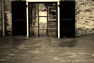
Floods in the Netherlands and Evacuation (2012 January)
Size and Scale of Flooding
Flood warnings have been notified at the west coast of the Netherlands. Number of Dutch people were then asked to evacuate the area as the estimated size and the scale of the floods are notbly dangerous. 100 people were leaving their homes when the corruption of the dykes were approaching. The Netherlands was not the only country suffering from the upcoming flooding incident. Other countries in Europe such as the UK, Belgium, France and Germany were at risks as well. In northern England, winds up to 178km/h were recorded. 11 ships were ceased from docking due to high water level.
Dutch soliders and the police evacuated 800 people from the northern area of the Netherlands. One of the inland dykes was found damaged and water was leaking out of it and it is highly likely to collapse when heavy rain falls. Despite having thousands of sandbags, some leakage of the dykes have allowed the water to enter the town. The government was trying to ensure that the residents are safely transferred into the safe zone before the peak flow. Meanwhile, the military troop as well as the residents carried sandbags to the dyke to plug the leaks. It was essential to keep the dyke in safe position as once it break, the damage made from it will be incontrollable, said a local official-- Yvonne van Mastrigt.
Localized Floods Incident (2007)
The Netherlands was strike by a localized flooding after a heavy thunderstorms and rain have passed by. The floods were resulted as the drains were not capable to to deal with the great volume of the water. The capital city of the Netherlands, Amsterdam as well as Rotterdam were busy coping with the emergency situations. In addition to the heavy precipitation, lightenings have caused fire in the cities. This incident has ceased the activities at the airport. This sudden but brief rainstorm that has caused localized flooding are later found out that is caused by the warm temperature during the spring season that has caused increase in heavy shower. The incident has killed two people in total during the storms as well as the flooding. One of the victims could not escape from the lightening and was hit by it.
